
NV plotter cartography - inland

€63.95*
% €69.90* (8.51% saved vs. recommended price)will be ordered for you
Product number:
1924305
EAN:
4250327474183
Manufacturer product ID:
9844
Please note that our English product descriptions are automatic translations from German. If anything is unclear, please contact us and/or double check the description by the manufacturer. Thanks for your understanding! - your Klabauter Crew
Product information "NV plotter cartography - inland"
NV plotter charts - NV Seekarten for card plotter
The NV plotter charts are stored on & mu; SD card and flexibly used according to the plug & play principle on compatible devices.
You have an identical card image like the well -known NV paper cards.
The nautical charts of the NV publishing house offer particularly high -quality cartography and many details, especially outside the main fairway, as well as in natural ports. NV Seekarten have a red 2m line for a better overview. Each card is created from the best available data. Sea cards of the NV publisher are read correctly and meet the highest demands, in many cases with exclusive own measurement data.
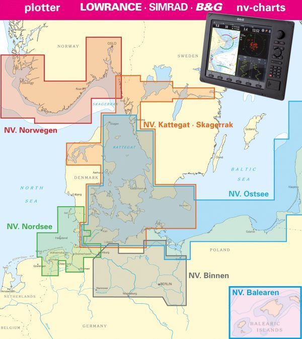
The NV plotter charts are divided into areas and contain all the necessary cards and harbor plans.
The NV-Plotter charts contain a free code for using the NV Charts app.
NV plotter charts run on these devices:
-Lowrance - all devices of the HDS series Gen. 1 and 2
-Imrad - NSE · NSS · NSO
-B & g - all devices of the Zeus series
High -quality cartography
-Luminous Fire sectors are presented precisely
-Main fairway marked with minimum depths
-rote 2 meter line
-Gut presented editorial content (4 cartographers and 5 nautics hydrophraphs)
-Blatt cut -free card display
The NV plotter charts are stored on & mu; SD card and flexibly used according to the plug & play principle on compatible devices.
You have an identical card image like the well -known NV paper cards.
The nautical charts of the NV publishing house offer particularly high -quality cartography and many details, especially outside the main fairway, as well as in natural ports. NV Seekarten have a red 2m line for a better overview. Each card is created from the best available data. Sea cards of the NV publisher are read correctly and meet the highest demands, in many cases with exclusive own measurement data.
The NV plotter charts are divided into areas and contain all the necessary cards and harbor plans.
The NV-Plotter charts contain a free code for using the NV Charts app.
NV plotter charts run on these devices:
-Lowrance - all devices of the HDS series Gen. 1 and 2
-Imrad - NSE · NSS · NSO
-B & g - all devices of the Zeus series
High -quality cartography
-Luminous Fire sectors are presented precisely
-Main fairway marked with minimum depths
-rote 2 meter line
-Gut presented editorial content (4 cartographers and 5 nautics hydrophraphs)
-Blatt cut -free card display